Water Well Map Data
Welcome to the data information page of Water Well Map. Here, we compile comprehensive data on water wells across various states in the United States. Our database includes geolocation information, depth details, and other relevant data, all sourced from public records. Browse through the states listed below to access specific well data in your region of interest.
State Data Sources
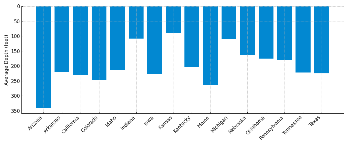
Arizona
The major aquifer in Arizona is the Central Arizona Basin. This aquifer is part of the larger Basin and Range aquifers, which are prevalent in the southwestern United States.
Arizona has 173,299 wells in our database with an average depth of 342 feet.
Source: Arizona Department of Water Resources
Arkansas
The Mississippi River Valley Alluvial Aquifer is the primary aquifer in Arkansas, important for both agricultural and municipal uses.
Arkansas has 89,369 wells in our database with an average depth of 220 feet.
Source: Office of the State Geologist
California
California's primary aquifers include the expansive Central Valley Aquifer System, crucial for agriculture, and the Coastal Basin Aquifers, vital for the densely populated coastal regions. Other significant aquifers are the Basin and Range, Sierra Nevada, and Colorado River Basin Aquifers, which support local communities and ecosystems in their respective areas.
California has 744,195 wells in our database with an average depth of 231 feet.
Source: California Natural Resources Agency
Colorado
The Denver Basin aquifer system is a significant groundwater source in Colorado, especially for the Denver metropolitan area.
Colorado has 360,330 wells in our database with an average depth of 247 feet.
Source: Colorado Division of Water Resources (DWR)
Idaho
The Eastern Snake River Plain Aquifer is the main aquifer in Idaho, providing substantial water for both agricultural and domestic use.
Idaho has 131,273 wells in our database with an average depth of 213 feet.
Source: Idaho Department of Water Resources
Indiana
The major aquifer in Indiana is the Sand and Gravel Aquifer, found mostly in the northern part of the state. It's part of the larger Glacial Deposits aquifers.
Indiana has 397,681 wells in our database with an average depth of 108 feet.
Source: Indiana Department of Natural Resources
Iowa
The major aquifer in Iowa is the Cambrian-Ordovician Aquifer System, which supplies a significant portion of the state's groundwater.
Iowa has 35,035 wells in our database with an average depth of 226 feet.
Source: Iowa Department of Natural Resources
Kansas
The High Plains Aquifer, specifically the Ogallala portion, is the major aquifer in Kansas, crucial for agriculture.
Kansas has 296,858 wells in our database with an average depth of 90 feet.
Source: Kansas Geological Survey
Kentucky
The Mississippian Carbonates Aquifer is a key water source in Kentucky, especially in the central part of the state.
Kentucky has 208,188 wells in our database with an average depth of 202 feet.
Source: Kentucky Geological Survey
Maine
The major aquifer in Maine is the Sand and Gravel Aquifer, which is widespread throughout the state.
Maine has 81,751 wells in our database with an average depth of 263 feet.
Source: Maine Geological Survey
Michigan
The Michigan Basin is the primary aquifer system in Michigan, significant for both residential and industrial water supply.
Michigan has 919,024 wells in our database with an average depth of 110 feet.
Source: Michigan Department of Environment, Great Lakes, and Energy
Nebraska
The High Plains Aquifer, particularly the Ogallala Aquifer, is the most extensive aquifer in Nebraska, vital for irrigation.
Nebraska has 245,566 wells in our database with an average depth of 163 feet.
Source: Nebraska Department of Natural Resources
Oklahoma
The Ogallala Aquifer and the Arbuckle-Simpson Aquifer are major groundwater sources in Oklahoma, with the latter being critically important for the south-central region of the state.
Oklahoma has 118,707 wells in our database with an average depth of 176 feet.
Source: Oklahoma Water Resources Board
Pennsylvania
The major aquifer in Pennsylvania is the Valley and Ridge Aquifers, found predominantly in the eastern and central parts of the state.
Pennsylvania has 379,230 wells in our database with an average depth of 181 feet.
Source: Pennsylvania Department of Conservation & Natural Resources
Tennessee
The Mississippi Embayment Aquifer System is a significant groundwater source in Tennessee, especially in the western portion of the state.
Tennessee has 162,474 wells in our database with an average depth of 222 feet.
Source: Tennessee Department of Environment & Conservation
Texas
The Edwards Aquifer in central Texas and the Ogallala Aquifer in the panhandle are two of the most significant aquifers in Texas, both critically important for water supply in their respective regions.
Texas has 625,052 wells in our database with an average depth of 225 feet.
Source: Texas Water Development Board
Data is collected from public sources. No warranty, expressed or implied, is made by Water Well Map or Gammastream Technologies, Inc. as to the accuracy of the data and related materials.